

LNU Lightning Complex Fire: One more death reported bringing death toll to five
SOLANO, Calif. - One more death has been reported in Solano County as a result of the LNU Lightning Complex Fire, Cal Fire crews reported Monday, bringing the death toll to five as a result of these wildfires raging through the North Bay.
As of Monday evening, Cal Fire said 351,817 acres had burned, or 547 square miles and they had 25% of it contained. This complex of fires is now the largest complex being battled in California.
More than 1,000 structures have been either destroyed or damaged and 30,500 structures remained threatened.
UPLOAD YOUR PICTURES TO THE KTVU WEATHER APP
KTVU took new video on Monday morning from the Armstrong Redwoods State Natural Reserve north of Guerneville, where tall trees were seen ablaze.
But later on Monday, the National Weather Service canceled its Red Flag Warning, saying that moisture had moved into the area and the "instability" had moved out, meaning that the lightning strikes were not on the immediate horizon.
Firefighters are well aware that people want to go back home.
"We are working hard to get you back home as quickly as possible," said Cal Fire Unit Chief Shana Jones. "We'll get there."
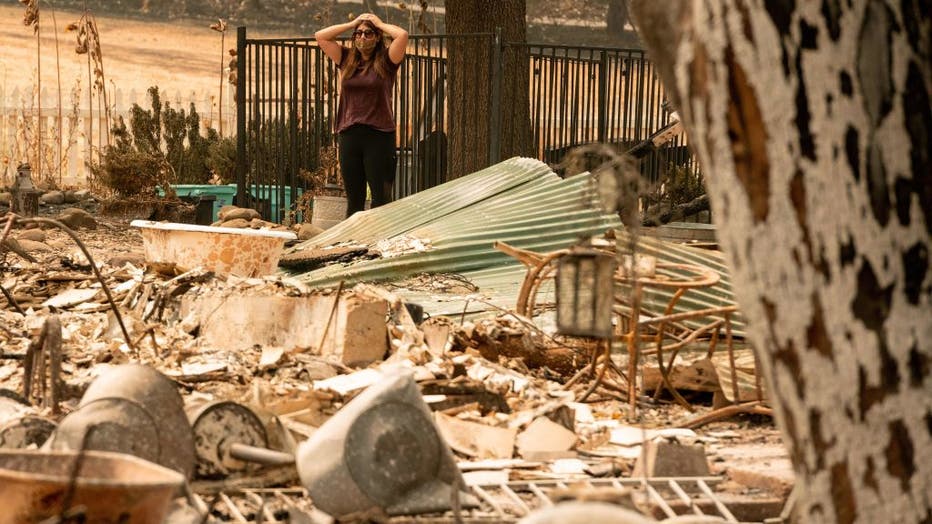
Resident Alyssa Medina reacts while looking over the charred remains of her family home during the LNU Lightning Complex fire in Vacaville, California on August 23, 2020. (Photo by JOSH EDELSON/AFP via Getty Images)
But she also stressed patience.
Cal Fire crews have several priorities to battle before letting people go back home.
One is controlling the Walbridge Fire west of Healdsburg, a 67-square mile fire within the complex, which is hard to access because of the tough terrain.
Cal Fire also has a lot of crews and engines above Calistoga, where part of the Hennessey Fire is burning, to keep it from spreading.
Interactive map: See where wildfires are burning across the Bay Area
CZU August Lighting Complex Fire: No imminent danger to Santa Cruz or UC campus
70-year-old man found dead; wildfires rage through Northern California
California inmates battling wildfires despite COVID-19, early releases
'Sickening': Firefighter has wallet stolen, bank account drained during Santa Cruz fire fight
EVACUATIONS:
Napa County:
OES Info: https://www.countyofnapa.org/353/Emergency-Services
Evac Info: https://www.countyofnapa.org/CivicAlerts.aspx?AID=182
Napa County Information Line: (707) 253-4540
https://www.countyofnapa.org/2966/19746/LNU-Wildfires
Evacuation Order:
Highway 128 between Monticello Dam and Moskowite Corners (SR128/121 intersection)
Wragg Canyon
Markley Cove
Pleasure Cove
Moskowite Corners area
Community of Circle Oaks
Wooden Valley Road areas
Steel Canyon Road
Community of Berryessa Highlands
Chiles and Lower Chiles Pope Valley Roads
Berryessa-Knoxville Road from Hwy128 (at Turtle Rock) to Lake County Line
Community at Spanish Flat Loop Road
Community of Berryessa Pines
Both sides, including resorts and recreational areas of Lake Berryessa, Knoxville
Deer Park Road from Silverado Trail, east to Howell Mountain Road
Community of Deer Park
St. Helena Hospital
Howell Mountain Road, east to Pope Valley
Community of Angwin
Pacific Union College
All of Pope Valley Road and connecting roads
Pope Valley Cross
Hardin
Aetna Springs Road
James Creek Road
All of Butts Canyon Road and connecting Roads in Napa County of Napa
Snell Valley Road
Stagecoach Road
Community of Berryessa Estates
Properties on roads east of Silverado Trail North, between Rosedale Road and SR128 (Sage Canyon Rd)
Glass Mountain Road
Crystal Springs Road
Lommel Road
Dutch Henry Road
Pickett Road
Clover Flat Road
Properties on the east side of Highway 29 between Silverado Trail and Lake County line
Old Lawley Toll Road
Palisades Road
Atlas Peak Road, east to the dead end
Evacuation Warning:
Highway 121 (Monticello Road) from Vichy Avenue to Longhorn Ridge Road, to include the Circle Oaks sub-division, along with the communities of Wooden Valley and Gordon Valley to the Napa/Solano County line
Soda Canyon Road from Loma Vista to 3700 Soda Canyon Road (Dead End)
Atlas Peak from the Bubbling Wells Pet Cemetery 2462 Atlas Peak Road to 3683 Atlas Peak Road (Circle R Ranch)
Evacuation Lifted:
Evacuation Orders have been lifted and are no longer in effect for the portion of Silverado Trail between Rosedale Road and Highway 29.
Evacuation Orders on Highway 29 from Silverado Trail to the Lake County Line, excluding the portion within the Calistoga City Limits, remain in effect.
The Evacuation Warning along Highway 121 (Monticello Rd) from Vichy Ave to Silverado Trail is lifted and no longer in place.
All other Evacuation Orders and road closures remain in place.
Sonoma County:
Residents and visitors can dial 2-1-1
You can also view an interactive evacuation map at . https://arcg.is/0buuL1
Livestock 707-234-7193.
The following areas are downgraded from Evacuation Order to Evacuation Warning:
Map Grid 1D1 downgraded to Evacuation Warning
East of the Sonoma Coast
North of the Russian River
West of Myers Grade Road
South of Fort Ross Road
Map Grid 1D2 downgraded to Evacuation Warning
East of Myers Grade Road
North of the Russian River
West of Cazadero Highway
South of Fort Ross Road
NOTE: People returning to the area must utilize Hwy 1 to return to their homes. Hwy 116 remains closed east of Cazadero Highway.
Evacuation Order:
Evacuation Zone - 1D3
East of the Austin Creek
North of Russian River
West and South of Old Cazadero Road
Evacuation Zone - 1D4
East of Old Cazadero Road
North of Russian River
West of Armstrong Woods Road and Sweetwater Springs Road
South of McCray Ridge Road and Pool Ridge
Evacuation Zone - 1D5
East of Armstrong Woods Road
North of the Russian River
West of Westside Road
South of Sweetwater Springs Road
Evacuation Zone - 1B3
East of McCray Ridge Road and Pool Ridge
North of Old Cazadero Road
West of King Ridge Road
South Skaggs Springs Road
Evacuation Zone - 1F2
All areas south of the Russian River
East and North of Hwy. 116 (Pocket Canyon)
West of Martinelli Rd.
Evacuation Zone - 2A3
North of Stewarts Point Skaggs Springs Road to the eastern edge of Lake Sonoma
Everything west of the eastern edge of Lake Sonoma to the western boundary that runs north along the ridge line from the intersection of Stewarts Point Skaggs Springs Rd @ Old Stewarts Point Skaggs Springs Road to the interception of Rockpile Road @ Cooley Ranch Road north to the Mendocino County Line. This is a very rural area with no clear defining boundaries.
Evacuation Zone - 2E1
South of Stewarts Point Skaggs Springs Road
North of Palmer Creek Road and Stewart Point Skaggs Springs Road
West of McCray Road
East of Wallace Creek Road
Evacuation Zone - 2E2:
South of Stewarts Point Skaggs Springs Road
North of Chemise Road
West of the center of Dry Creek (the actual creek)
East of Wallace Creek Road
Evacuation Zone - 2E3
South of Chemise Road
North of Westside Road
East of Wallace Creek Road
West of the Center of Dry Creek (the actual creek)
Evacuation Zone - 2E4:
South of Palmer Creek Road
North of McCray Ridge Road and Sweetwater Springs Road
East of the Dry Creek (the actual creek)
Evacuation Zone - 4B1
All areas south of River Rd. from Martinelli Rd. to the intersection of River Rd at Trenton Rd.
West of Covey Rd.
North of Front St. / Hwy. 116
East of Martinelli Rd.
Evacuation Zone - 4D1
South of Pocket Canyon/Hwy 116
East and North of Green Valley Road
West of Atascadero Creek
Evacuation Warning:
West of Meyers Grade Rd to the coast
South of Fort Ross Road
North of Russian Gulch State Beach
North of Austin Cree Recreational Area
East of Cedars
West of Mill Creek Rd
South of Stewarts Point-Skaggs Spring Rd
Evacuation Zone 1F1
All areas east of Bohemian Hwy.
North of Graton Rd. and Harrison Grade Rd.
West of Harrison Grade Rd., Green Valley Rd., and Hwy. 116
South of the Russian River
Evacuation Zone 1F2
All areas south of the Russian River
East and North of Hwy 116 (Pocket Canyon)
West of Martinelli Rd.
Evacuation Zone 4A1
All areas East of the Russian River
North of River Rd.
West of Trenton Healdsburg Rd. and Eastside Rd.
South of the area between the western dead end of Windsor River Rd. and the Russian River
Evacuation Zone 4B1 (Northern Forestville)
All areas south of River Rd. from Martinelli Rd. to Trenton Rd.
West of Covey Rd.
North of Front St. / Hwy 116
East of Martinelli Rd.
Evacuation Zone 2K2
All areas south of Hwy. 101
East of the Russian River to the Windsor Town limits
North of where Windsor River Rd. dead ends extending west to the Russian River.
Evacuation Zone 1E3
All areas south of the Russian River
West of Bohemian Hwy.
North and East of Coleman valley Rd. and Willow Creek Rd.
Evacuation Zone 1E1
All areas south and west of Willow Creek Rd.
North of Coleman Valley Rd. and Wright Hill Rd.
East of the California Coastal National Monument (BLM property)
Evacuation Zone - 1C1
All areas east of the Sonoma coast to the south fork of the Gualala River.
South of Kruse Ranch Rd. and Howser Bridge Rd. to Fort Ross Rd
Evacuation Zone - 2A3
North of Stewarts Point Skaggs Springs Road to the eastern edge of Lake Sonoma
Everything west of the eastern edge of Lake Sonoma to the western boundary that runs north along the ridge line from the intersection of Stewarts Point Skaggs Springs Rd @ Old Stewarts Point Skaggs Springs Road to the interception of Rockpile Road @ Cooley Ranch Road north to the Mendocino County Line
Evacuation Zone - 4B1
All areas south of River Rd. from Martinelli Rd. to the intersection of River Rd at:
Trenton Rd.
West of Covey Rd.
North of Front St. / Hwy. 116
East of Martinelli Rd
Evacuation Zone - 4A2
East of Trenton Healdsburd Road
North of Mark West Station Road
West of the Windsor City Limits and Windsor Road
South of Windsor River Road
Evacuation Zone - 4A3
East of Trenton Healdsburg Road
North of River Road
West of Slusser Road
South of Mark West Station Road
Evacuation Zone - 2A2
North of the Dry Creek and the norther fork of Lak Sonoma County
West of Dutcher Creek, City of Coverdale city limits and Hwy 128
South of the Mendocino County line
Evacuation Zone - 2C4
South and West of Asti Road
East of Hwy 101
North of Hwy 128
Evacuation Zone - 2G1
East of Hwy 101
South and West of Hwy 128
North of Alexander Valley Road
Town of Windsor - Zone A
North of Windsor River Road
West of Hwy 101
All to the Western and norther town limits west of 101
Map Grid 2F1 downgrade to Warning
East of Dutcher Creek Road and the Dry Creek (the actual creek)
North of Canyon Road
West of Hwy 101
Map Grid 2F2 downgrade to Warning
South of Canyon Road
East of the Dry Creek (the actual creek)
North of Lytton Springs Road
West of Geyserville Avenue
Map Grid 2F3 downgrade to Warning
South of Lytton Springs Road
East of the Dry Creek (the actual creek)
North of Westside Road
West of the Healdsburg city limits.
Map Grid 2K1 downgrade to Warning
All areas North and East of Westside Rd.
West of Hwy. 101
West of the Russian River
Map Grid 2K2 downgrade to Warning
All areas west of Hwy. 101
East of the Russian River to the Windsor Town limits
North of where Windsor River Rd. dead end extending west to the Russian River.
Map Grid 4A1 downgrade to Warning
All areas East of the Russian River
North of River Rd.
West of Trenton Healdsburg Rd. and Eastside Rd.
South of the area between the western dead end of Windsor River Rd. and the Russian River
Map Grid 4C1 downgrade to Warning
North of Guerneville Road
East of Covey Road and Hwy 116
West of Laguna Rd
South of River Road
City of Healdsburg
The Evacuation Order for the residents in the City of Healdsburg West of Highway 101 off of Chiquita Road has been reduced to an Evacuation Warning. This includes Chateau Real, Matteri Rd, Burgundy Rd, Chablis Rd, Zinfandel Rd, and Riesling Rd.
All areas in the city of Healdsburg East of Highway 101 remain on an Evacuation Warning.
Lake County:
https://www.facebook.com/lakesheriff/
Evacuation Map:HERE
OES Contact:
(707) 262-4090
Sign Up for Lake County Alerts:
https://member.everbridge.net/index/892807736729003#/signup
Evacuation Orders:Hidden Valley Lake / Jerusalem Valley Areas
North of Butts Canyon
South of Hofacker Ln. to Morgan Valley Rd.
East of Hwy 29
West of Lake / Napa County line
East of Middletown Area
East of Hwy 29
North of Lake / Napa County line up to the intersection of Hey. 29 and St. Helena Creek (Across from Twin Pine Casino)
St. Helena Creek Rd
South of Butts Canyon Rd.
Lower Lake Area (South)
East of Hwy. 29
South of Morgan Valley Rd.
West of Lake / Napa County line
North of Hofacker Ln. extending east to Morgan Valley Rd. Lower Lake Area (North)
North of Morgan Valley Rd.
East of Sky High Ridge Rd. extending north to Hwy. 20
South of Hwy. 20
West of Lake / Napa / Colusa County lines
Evacuation Warnings:
Middletown Area
West of Hwy. 29
North and East of Lake / Napa
South of Anderson Springs Rd. / Neft Rd. / Boggs Mt. Rec. Area extending northeast to Hwy. 29 / Hofacker Ln.
Lower Lake Area
East of Big Canyon Rd. / Perini Rd. / Seigler Canyon Rd.
South and west of Hwy. 29
North of the previous evacuation order / warning line of Anderson Springs Rd. / Neft Rd. / Boggs Mt. Rec. Area extending northeast to Hwy. 29 / Hofacker Ln.
Solano County:Evacuation Lifted:Evacuation Orders for the following areas of Solano County have been lifted and are no longer in effect: unincorporated Fairfield and Suisun (except Lyon Road), including Green Valley, and portions of Allendale and English Hills east of the existing fire perimeter.
Evacuation Center:
Napa County:
Crosswalk Community Church
2590 First Street
Napa, CA 94558
Sonoma County:
Temporary Evacuation Point
Santa Rosa Fairgroundss
1350 Bennett Valley Road
Santa Rosa, CA 95404
Petaluma Veterans Building
1094 Petaluma Blvd
South Petaluma, CA 94952
Lake County:
Temporary Evacuation Point (TEP)
Kelseyville High School parking lot 5480 Main Street Kelseyville, CA
Animal Evacuation Center:
Napa County:
Napa County Animal Shelter
942 Hartle Court
Napa, CA 94559
Valley Brook Equestrian Center 1132 El Centro Ave. Napa 55 horses
Napa Valley Horseman's Association, 1200 Foster Road Napa 61 horses
Ag 4 Youth 1200 Foster Rd, Napa 62 Ruminants
Solano County
Vallejo Fairgrounds, 900 Fairgrounds Drive, Vallejo (large animals, current count 211 animals)
Solano County Animal Shelter, 2510 Claybank Rd (small animals only, current count 285 animals)
Kelseyville High School parking lot 5480 Main Street Kelseyville, CA
Road Closures:
Napa County:
SR-121 at Wooden Valley Rd (this was previously the SR-121 at SR-128 closure). This closure will be staffed by an officer. Circle Oaks is being or will be evacuated
SR-128 at Pleasent's Valley Rd. Woodland CHP and Caltrans are staffing this closure. No traffic westbound on SR-128 from this intersection. Traffic can move east on SR-128 and south on Pleasent's Valley Rd
Butts Canyon Rd at Snell Valley Rd. This closure is staffed by a CHP officer. We do not want anyone traveling south on Butts Canyon Rd past this intersection
SR-128 at Silverado Trail. This closure is staffed by a CHP officer and Caltrans
Napa County Roads is working on the following closures:
Atlas Peak Rd at Westgate Drive. No traffic north on Atlas Peak Rd. past Westgate Drive. This section of Atlas Peak is being or will be evacuated
Soda Canyon Rd at Silverado Trail. Soda Canyon Rd. north of Loma Vista Drive is being or will be evacuated. We do not want any traffic on Soda Canyon Rd north of Loma Vista--it's easier to close it at Silverado Trail
Sonoma County:
SR-1 @ Fort Ross Road- No traffic on S/B SR-1 and no traffic E/B on Fort Ross Rd
SR-1 @ Meyers Grade Road- No traffic on N/B SR-1 and no traffic on N/B Meyers Grade Rd
Fort Ross Road at Seaview Road- No traffic on W/B Fort Ross Rd. and no traffic on E/B Fort Ross Rd
Myers Grade Road at Fort Ross Road- No traffic on S/B Meyers Grade Rd
Dry Creek Rd at Dry Creek
Yoaking Bridge Rd at Dry Creek
Lyton Springs Rd at Dry Creek
Westside Rd @ Dry Creek
Wohler Rd at River Rd
Odd Fellows Park Rd at Russian River
Bohemian Hwy at Russian River
Mosscow Rd at Hwy 116
Hwy 116 at Hwy 1 (Move Hwy 1 at Myers Grade)
King Ridge Rd @ Sewell Rd (private Rd with gates)
Skaggs Spings Rd at Sewell Rd (Anvil Ranch)
Solano County
Auburn Road at Foothill Road
Brown’s Valley at Shelton
Putah Creek Road at Winters Road
Cherry Glen Road at Lyon Road
Mankas Corner Road at Rancho Solano Parkway
Suisun Valley Road at Rockville Road
Abaernathy Rd. N/ Rockville Road
N. Orchard Avenue at Vaca Valley Road
Pleasants Valley @ SR-128
Gibson Canyon Road at Fruitvale Road
Cherry Glen Road at Pleasants Valley Road
Timm Road at Peaceful Glen Road
Gibson Canyon Road at Farrell Road
Rollingwood Drive at Lyon Road
Suisun Valley Road at Lambert Road
Browns Valley Road at Cantelow Road
Rice Lane north of Aldridge Road
Clancy Lane west of Timm Road
Rockville Rd. @ Suisun Valley Road
Suisun Valley Rd. S/ Rockville Road
Cherry Glen Rd. @ Lyon Road
Cantelow Rd. @ Timm Road
Green Valley Rd. @ Rockville Road
Gibson Canyon Rd. @ Vine
Damages and Losses
Confirmed Damage to Property, Injuries, and Fatalities