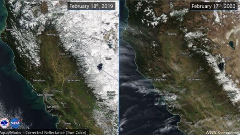
Side-by-side photos: Sierra snow pack below normal, drought returns to California

Left: 2019, Right: 2020. Sierra snow pack is below normal for this time of year, at about 58% statewide. Dry weather is expected to continue. Feb. 18, 2020
OAKLAND, Calif. - Aerial images over the Sierra taken this week show that the snow pack is below normal for this time of year, as scientists say drought has returned to California due to a significantly dry winter.
The National Weather Service tweeted out side-by-side NASA photos showing the difference in snow over the Northern California mountains comparing Monday to about the same time last year. Last year's photo showed a lot of white snow over the Sierra. This year's photo showed a lot of brown and green hills. According to the weather service, the snowpack is 58 percent below normal this time of year.
The photographs come after the U.S. Drought Monitor released a weekly report last week designating just over 9.5% of the state, including the central and southern Sierra Nevada and adjacent areas of the Central Valley, as being in moderate drought.
Download our new and improved mobile app
California had been drought-free since the early December.
The Drought Monitor also expanded a designation of “abnormally dry” into San Luis Obispo, Santa Barbara, Ventura and Los Angeles counties, and parts of northeastern California.
A week earlier, the abnormally dry status applied to the Central Valley and a swath from the San Francisco Bay Area to the Sierra, as well as parts of the California-Oregon border.
In particular, the monitor pointed to precipitation deficits in central and southern sections of coastal California and in the central and southern Sierra, and a snowpack that is less than 60% of normal to date.
The National Weather Service said there is no change in the dry pattern through the month of February. And if there’s no rain, many locations will be nearing the driest combined January and February on record.
State water authorities have noted that, fortunately, reservoirs are either at or above historical averages due to a wet 2019.
The Associated Press contributed to this report.

