


Rain returns
Rain returns on Friday and will extend through Christmas.

North Bay rain showers to develop overnight
The Bay Area is bracing for some rain activity with precipitation first developing in the North Bay around midnight.

Cloudy, cool
Today will be cloudy and cool with temps in the 50s in San Francisco.

Rain today and record warmth
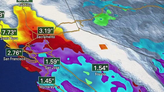
How about that! Rain today and record WARMTH! Today across the San Francisco Bay Area, temperatures ran well above average for mid-December. Highs ranged from 61° in San Francisco to 72° in Redwood City and Morgan Hill. San Jose topped out at 71°, while Concord reached 67°, breaking the previous record of 66° set 25 years ago in 2000. This warmth arrived alongside our first measurable rain after 26 consecutive dry days. A weak, warm storm system moved through the region, producing 0.18 inches of rain in Oakland and up to .35 inches in San Francisco and La Honda, helping to briefly ease very dry conditions. A Dense Fog Advisory is in effect for the Monterey Bay region — including Capitola — until 9 PM tonight. Visibility has been locally reduced, especially near the coast. Tonight Expect patchy fog and mostly cloudy skies, with overnight lows dropping into the 40s. Thursday, morning fog and low clouds will give way to partly cloudy skies during the day, followed by increasing clouds Thursday night ahead of the next system on Friday. A much wetter and more unsettled pattern sets up late week into next week:

Fog and rain
Today will see fog and rain, with temps in the 60s.

A change in the weather
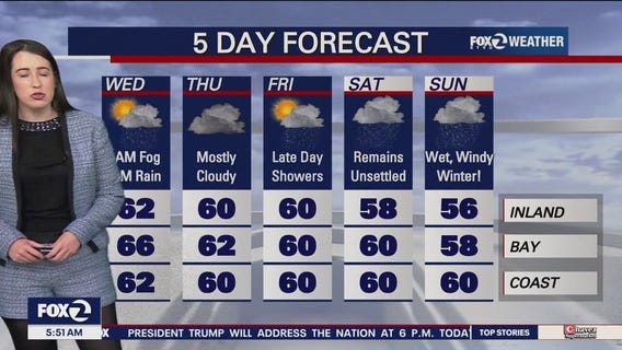
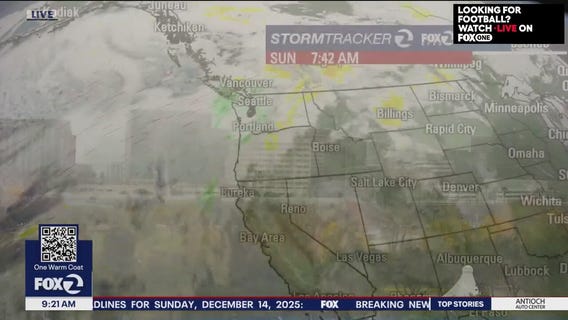
Day 26 No rain....Day 25 of Tule fog! Less Tule fog tonight overnight in the East and North Bay, but wake up Wednesday morning to mostly cloudy skies, spotty light rain and patchy fog. Wednesday afternoon will be dry with some sunny breaks. Mild temps in the 50s and 60s. Looks like Friday through Sunday will be our wettest days, with Sunday, the first day of Winter, wet and windy!


Mostly cloudy, chance of showers
Today will be mostly cloudy and there is also a chance of showers.


Weather pattern is changing
The stable, dry pattern that has been responsible for all of the stubborn fog is moving out of town. There is high confidence that a series of storms will drop into Northern California for the rest of December. The first weak system moves in Tuesday. Shower chances will be favoring the North Bay, Highs should range from the mid 50s to the mid 60s. Shower chances will be highest late Tuesday - Wednesday morning. System 2 could be arriving Friday. The wet weather pattern could linger into the weekend. We are tracking a potentially strong storm early next week.
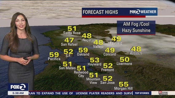

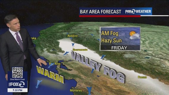
Fog, hazy sunshine
Today will see fog and hazy sunshine.


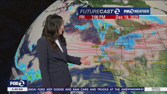
Changes to Bay Area weather are coming this weekend
Monday will be similar to today's cool temperatues with slow burn off of the tule fog and misty morning conditions. High clouds that are expected to flow over the region, increasing the breeze and hopefully scouring the tule fog out a bit earlier each day. The BIG news is the weather pattern change beginning on Tuesday. Exact timing and amounts are not certain, but rain arrives to the Bay Area, with the heaviest rain Friday through Sunday.

Cloudy and cool persists
The cloudy, cool weather will continue today with patchy dense fog for our inland cities. Afternoon highs will range from upper 40s inland to low 60s around the bay. Chance of showers enter the Bay Area later this week.

Another round of fog
Our persistent weather pattern will stick around for a couple of more days. Low clouds and fog will resurface Sunday morning. Partly sunny skies are expected later in the day. Fog patches could linger in some of the inland valleys. Highs should range from the upper 40s to the low 60s. After a long dry stretch, we are finally tracking some rain for next week. The days we are watching are Tuesday, Wednesday, and Friday. A stronger storm could move in next weekend.

Subtle changes today, bigger changes next week
For today, low clouds at the coast, Tule fog inland with cool temperatures for the afternoon, ranging from upper 40s in our valleys to low 60s around the bay. Wet weather is scheduled to return next week.

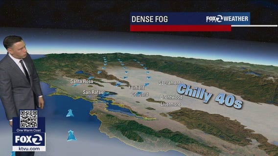
Fog and more fog
Saturday will be day 20 of dense Inland tule fog and 23 days without rain. More of the same on Saturday and Sunday until late Tuesday and Wednesday when light rain enters the Bay area. Until then, temperatures in the 40s and 50s where there is a deck of fog Inland, 50s and 60s elsewhere.

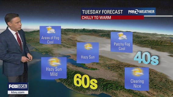
Chilly to warm
No big changes to the Bay Area forecast. Fog will resurface in the inland valleys Friday morning. The fog could linger into the afternoon. Sunshine and mild temperatures are expected for the remainder of the Bay Area. Highs should range from the upper 40s to the mid 60s. Your weekend will be dry. Rain chances could be going up early next week.

Where there is sun, it's nice
Repeat performance. Sunny and highs in the mid 60s at the Coast, Peninsula and South Bay. Where there is NO sun (due to tule fog), expect peaks of sun with highs only in the upper 40s and low/mid 50. This will include the North and East Bay inland areas. - Beach Hazard Alert in effect until Friday due to sneaker waves. - Moderate (hazy) air quality for all areas.

Stubborn fog and sun
Fog will linger in the same areas today...especially in parts of the North Bay. Highs should range from the upper 40s to the low 60s. A Breach Hazards Alert is in effect due to building swell. Our dry stretch continues. Rain chances could be increasing early next week.
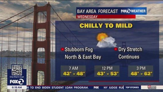

Chilly to mild
Highs in the upper 40s to low 60s today.

Fog clearing in some areas
Another big serving of fog for parts of the Bay Area Tuesday morning. While some neighborhoods are experiencing sunshine, the inland valleys and the North Bay continue to deal with fog. Highs today should range from the upper 40s to the low 60s. This pattern returns tomorrow. Rain chances could be increasing early next week.

Slightly warmer
Temps will be slightly warmer reaching low to mid-60s.