Temps above average
Today's temps will be well above average with highs reaching 80.
Warming Trend Continues
The Bay Area warming trend will continue. Look for full sunshine in the Thursday forecast. High should range from the low 70s near the coast to the upper 80s inland. Cooler temperatures are expected this weekend.
Sunny, warmer
Today will be sunny and warm wit highs in the mid-80s.
Warmer Wednesday
We are heading into another spring warming trend over the next several days. Gusty winds will resurface Wednesday morning. Gusts could approach 50 mph in the hills. Wednesday afternoon highs should range from the upper 60s near the coast to the low 80s well inland. The warming continues in the Thursday forecast.
Warming Up
We are heading into another spring warming trend over the next several days. Gusty winds will resurface Wednesday morning. Gusts could approach 50 mph in the hills. Wednesday afternoon highs should range from the upper 60s near the coast to the low 80s well inland. The warming continues in the Thursday forecast.
Little warmer
Today will be a little warmer with temps in the 70s and low 80s.
A notable warm up is on the way.
Good evening everyone. After a bit of a warm up this afternoon, a more notable change is coming in the days ahead. Click the link for your full forecast.
Chilly start, sunny afternoon
Today will start off chilly but become mostly sunny in the afternoon. Highs in the 70s.
Sunny, dry, cool
We have a dry, sunny, cool day is in store. Widespread 40s to start the morning. Upper 50s at the coast, low to mid 60s bayside, upper 60s inland
Rain moving out of town
Our unusually cold storm will be heading out of the Bay Area for the second half of the weekend. A spring pattern returns next week. Parts of the Bay Area will eventually warm into the 80s.
Tracking Saturday Rain
A cold system has produced widespread rain across the Bay Area. The rain should taper later today. Dry conditions return Sunday. Check out the latest storm updates from Meteorologist Mark Tamayo.
Rainy, Breezy and Cool Saturday.
Happy Saturday Everyone!! Rainy, breezy, cool conditions for the first part of the day. By afternoon the steady rain will taper to off and on showers followed by dry, chilly conditions tonight. In addition, snow in the Sierra with a Winter Weather Advisory for trvallers until tomorrow morning. Have a great day!
Rain Returns!
Our warm, spring pattern is coming to an end. A cold system will move into the Bay Area Saturday morning. Moderate to heavy rain, along with gusty winds, will highlight the Saturday forecast. A Winter Storm Warning has been issued for the Sierra this weekend!
Mostly sunny skies and afternoon highs ranging in the upper 50s coast-side and upper 70s inland.
Another enjoyable weather day before wet changes arrive tomorrow.
Fabulous Friday before soggy Saturday
Friday will be mild with temperatures in the 60s and 70s but rain will fall on Saturday.
No rain on Cinco de Mayo, Saturday is a different story
Rain on Saturday with cooler temperatures. Sunday's Cinco de Mayo forecast looks like we're in the clear.
Rain on the Way!
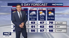
Our warm stretch will soon be coming to an end. Patchy fog resurfaces Friday morning. Highs should range from the low 60s near the coast to the upper 70s inland. A cold system moves in Saturday. Rain is expected to develop first thing Saturday morning.
Warm, rain ahead
Today will be warm with temps in the 80s. Rain ahead for Saturday and Sunday.
Rain on Saturday
Wet weather returns this Weekend with rain on and off Saturday. Sunday will be about clearing conditions and dry.
Warm Thursday
The mild to warm weather pattern will remain in place through Friday. A cool system will boost our rain chances by Saturday.


