

Unseasonably Cold Storm Threatens Scattered Thunderstorms Through Thursday
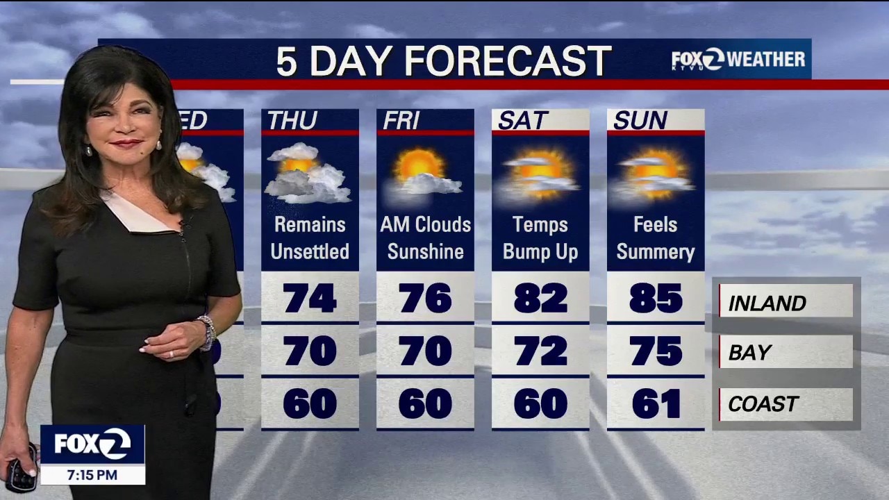
An unseasonably cold storm system is swirling directly over Northern California, generating a bizarre mix of rough seas, mountain gales, lightning and local rain. Tonight & Wednesday: Isolated Storms & Dangerous Coastlines The Storm Threat: Scattered showers and isolated thunderstorms are actively moving through the North Bay and East Bay with the highest lightning threat near Napa and Livermore through tonight. Mountain Gales: Gusts of 30–40 mph (and up to 50 mph) along the coast and across the North Bay & East Bay hills tonight. Dangerous Seas: Powerful gale-force winds are building massive, rough waves of 12-15 feet through Wednesday morning. Boaters and beachgoers must use extreme caution. Beach Hazard Statement in effect until 9 AM Wednesday. Wednesday: We do it all over again. Temperatures will stay chilly, only in the 50s and 60s at the coast and 60s to low 70s inland. Another round of scattered showers and a few weak afternoon thunderstorms will pop up, especially for the interior Bay Area.
Top Videos
Unseasonably Cold Storm Threatens Scattered Thunderstorms Through Thursday

Earthquake swarm strikes South Bay

CHP begins Thanksgiving holiday enforcement

Black Friday deals curbed by tariff-driven costs

Navigating holiday travel as a non-citizen

Laney College to make security upgrades

Officers detain teens with BB gun

Man receives 2 life sentences for brutal beating of "Grandma Huang"

Foster City man arrested in wife's cold case killing

Celebrating Native Culture: Oakland's Intertribal Friendship House

Older drivers' confidence plummets around age 70
Most Watched

Trump-Zelenskyy Oval Office confrontation

Woman sought after kicking dog in Pittsburg

Patient files lawsuit Kaiser Permanente, alleges sexual assault during surgery

Trump marks 30 days in Oval Office | West Coast Wrap

Gas prices climb in California while they fall in other states

Hundreds of NOAA scientists fired

Arrests and guns seized in probe of Oakland carjacking tied to pot dispensaries

Protesters work to disrupt ICE raid | West Coast Wrap

San Jose teen killed by alleged gang members for wearing red


