DC prepares for first winter storm in 2 years as powerful blizzard eyes Midwest next week
BETHESDA, Md. (FOX 5 DC) - January 3, 2022, is a date that will live in the minds of some Virginia commuters for years to come, as it was the night nearly a foot of snow shut down a stretch of Interstate 95 in Virginia, forcing some to wait out the storm in their cars.
Now, nearly two years later, the D.C. region is dealing with its first widespread winter storm since that fateful day.
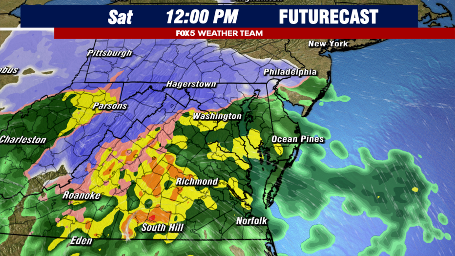
The FOX 5 Weather Team has been watching this storm for over a week now, and overall not much has changed in terms of expectations.
The storm looks to move in on Saturday morning.
With overnight temperatures in many spots dropping below freezing, including 20s out to the west of town, the ground will be cold enough to welcome any snow that happens to fall as the system moves in.
The snow is expected to start moving in from southwest to northeast between 7-9 a.m. It is likely to start, yes even here in metro D.C., as a period of snow.
The snow may come down steady enough to even coat the ground and some untreated roadways in a few places. The winter wonderland portion of this storm is not expected to last long though here in D.C. As the storm intensifies to our south, southern winds will push warmer air off the Atlantic inland, pushing the rain/snow line westward as well.
CLICK HERE FOR WEATHER RADAR FOR DC, MARYLAND AND VIRGINIA
Our expectations for the winter storm have not changed much since we first released our numbers on Tuesday night.
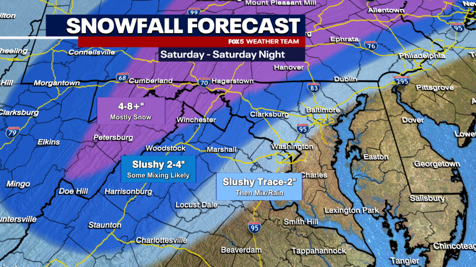
While initially there could be a coating to an inch or two around the immediate D.C. area, the change over to mix and rain will severely limit the snowfall potential close to the I-95 corridor.
As you get farther northwest, colder air is expected to hold on longer, and snowfall totals will be higher. As much as 4-8" in the mountains, with some higher elevations getting even more. This will not be light fluffy snow either, but wet and easily compacted snow.
READ MORE: DMV Winter 2023-2024 Outlook: Why we're expecting more snow, chance for blizzards in DC this winter
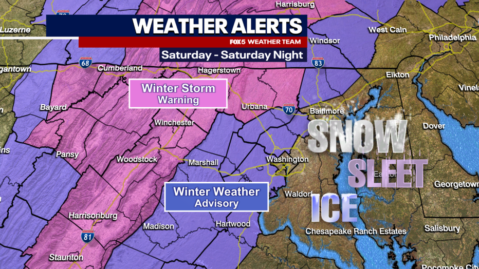
On Friday afternoon, winter storm warnings were issued for western parts of our viewing area, including the Maryland and West Virginia panhandles, the I-81 corridor, and those north.
Winter Storm Warnings are issued either where five or more inches of snow is possible, or where a lesser combination of snow and ice could lead to hazardous conditions.
Winter weather advisories, the first of this winter season, were put in place for Montgomery, Fairfax, Loudoun and most other counties in Northern Virginia. These are locations where light amounts of snow and sleet could lead to hazardous conditions.
READ MORE: Early snowfall expected Saturday before shift to rain across DC region
It's certainly recommended that those who do not have to be anywhere on Saturday avoid traveling, especially during the morning and early afternoon hours when the weather is expected to be at its worst.
This is a fast-moving system, and the latest projections are that it will exit our region between 4-7 p.m. on Saturday.
Sunday may feature a passing snow flurry but should be a mostly dry day for digging out and cleaning up after Saturday’s mess.
So what is next down the weather pipeline?
Well, the storm track remains extremely active, which is something very common in El Niño winters like this one.
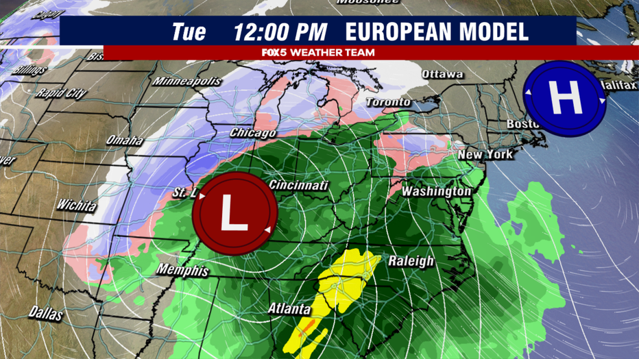
Tuesday is the next storm system that forecasters have an eye on. Weather models agree that this will be a monster storm for the eastern half of the country.
When news breaks, stream FOX 5 DC anytime. Get the FOX Local app on your smart TV.
Likely the first intense blizzard of the season, though the snow portion of this storm will be across the western and northern Midwest. Cities like Kansas City, St. Louis, Green Bay, and Chicago will have their eye on this storm.
Here in the D.C. region, depending on the timing of our storm, western parts of our region may have to deal with some morning sleet or freezing rain that could impact the morning commute. However, the big story for the East Coast about this storm will be the wind and the rain.
The National Weather Service is already warning about the risk of exceptionally heavy rainfall and flooding concerns. This will be one to keep an eye on early next week.
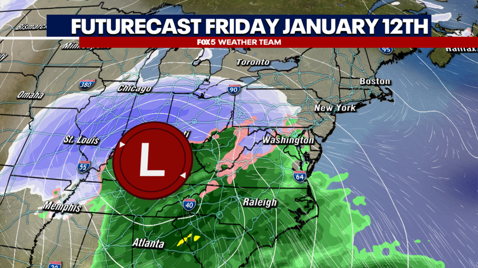
By the end of next week, yet another storm looks very likely to come our way, with a strong model agreement already of another following on the heels of Tuesday’s system in the Friday to Saturday time frame.
While the details of this system are hazy a week in advance, early indications are that it will be another cutter that passes our region west of the Appalachian Mountains.
Questions remain about the timing of this system, however, and how much cold air will be around ahead of the storm.
Parts of our region may once again be looking at a snow or ice-to-rain scenario. This will be one to keep an eye on heading into next week as well.
The FOX 5 Weather Team is here to help you get through them all. Be sure to stay up to date on the latest with the FOX 5 Weather App and check us out for free on Fox Local App on all major streaming platforms as well.

